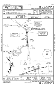
IAC chart of KDCA
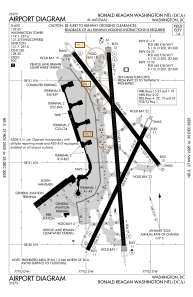
 ADC chart of KDCA
 Satellite view of KDCA
ADC chart of KDCA
Satellite view of KDCA
Sorry, we have no imagery here.
Sorry, we have no imagery here.
Sorry, we have no imagery here.
Sorry, we have no imagery here.
Sorry, we have no imagery here.
Sorry, we have no imagery here.


KDCA - Ronald Reagan Washington Ntl
Located in Washington, United States
ICAO - DCA, IATA - DCA
Data provided by AirmateGeneral information
Coordinates: N38°51'5" W77°2'16"
Elevation is 14 feet MSL.
Magnetic variation is -11° East View others Airports in District of Columbia
Operational data
Special qualification required
Current time UTC:
Current local time:
Weather
METAR: KDCA 211952Z 10007KT 3SM -DZ BR SCT007 OVC013 14/13 A2981 RMK AO2 DZB36 SLP094 P0000 T01440133
TAF: KDCA 211933Z 2120/2224 10010G18KT P6SM BKN016 OVC026 FM212300 09010G19KT 5SM -SHRA BR OVC008 FM220400 07007KT 4SM BR OVC006 FM220900 02004KT 5SM BR BKN006 BKN012 FM221100 25006KT P6SM BKN024 PROB30 2215/2217 6SM -SHRA BKN015 FM221700 28007KT P6SM SCT045 PROB30 2217/2220 6SM -SHRA BKN045 FM222000 30011G19KT 6SM -SHRA BKN045 PROB30 2223/2224 6SM -TSRA OVC019CB
Communications frequencies: [VIEW]
Runways:
| RWY identifier | QFU | Length (ft) | Width (ft) | Surface | LDA (ft) |
| 01 | 356° | 7169 | 150 | ASPH | 6869 |
| 19 | 175° | 7169 | 150 | ASPH | 6869 |
| 04 | 26° | 5000 | 150 | ASPH | 4800 |
| 22 | 206° | 5000 | 150 | ASPH | 4400 |
| 15 | 143° | 5204 | 150 | ASPH | 5204 |
| 33 | 323° | 5204 | 150 | ASPH | 5204 |
Airport contact information
Address: Washington United States
Satellite view of KDCA
Sorry, we have no imagery here.
Sorry, we have no imagery here.
Sorry, we have no imagery here.
Sorry, we have no imagery here.
Sorry, we have no imagery here.
Sorry, we have no imagery here.