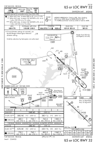
IAC chart of KDAA
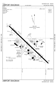
 ADC chart of KDAA
 Satellite view of KDAA
ADC chart of KDAA
Satellite view of KDAA
Sorry, we have no imagery here.
Sorry, we have no imagery here.
Sorry, we have no imagery here.
Sorry, we have no imagery here.
Sorry, we have no imagery here.
Sorry, we have no imagery here.


KDAA - Davison Aaf
Located in Fort Belvoir, United States
ICAO - DAA, IATA - DAA
Data provided by AirmateGeneral information
Coordinates: N38°42'54" W77°10'51"
Elevation is 73 feet MSL.
Magnetic variation is -09° East View others Airports in Virginia
Operational data
Special qualification required
Current time UTC:
Current local time:
Weather
METAR: KDAA 230755Z AUTO 27003KT 10SM FEW055 OVC120 13/11 A2980 RMK AO2 SLP094 T01280107 $
Communications frequencies: [VIEW]
Runways:
| RWY identifier | QFU | Length (ft) | Width (ft) | Surface | LDA (ft) |
| 14 | 133° | 5421 | 75 | ASPH | |
| 32 | 313° | 5421 | 75 | ASPH | |
| H1 | 0° | 0 | 0 | UNK |
Airport contact information
Address: Fort Belvoir United States
Satellite view of KDAA
Sorry, we have no imagery here.
Sorry, we have no imagery here.
Sorry, we have no imagery here.
Sorry, we have no imagery here.
Sorry, we have no imagery here.
Sorry, we have no imagery here.