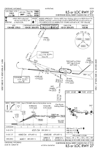
IAC chart of KCYS
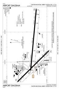
 ADC chart of KCYS
 Satellite view of KCYS
ADC chart of KCYS
Satellite view of KCYS
Sorry, we have no imagery here.
Sorry, we have no imagery here.
Sorry, we have no imagery here.
Sorry, we have no imagery here.
Sorry, we have no imagery here.
Sorry, we have no imagery here.


KCYS - Cheyenne Rgnl/Jerry Olson Fld
Located in Cheyenne, United States
ICAO - CYS, IATA - CYS
Data provided by AirmateGeneral information
Coordinates: N41°9'20" W104°48'38"
Elevation is 6159 feet MSL.
Magnetic variation is 10° East View others Airports in Wyoming
Operational data
Special qualification required
Current time UTC:
Current local time:
Weather
METAR: KCYS 212353Z 28019G31KT 10SM CLR 07/M11 A2996 RMK AO2 PK WND 28032/2330 SLP150 T00671106 10089 20056 53007
TAF: KCYS 212320Z 2200/2224 28020G30KT P6SM SCT070 FM220200 27010KT P6SM SCT150 FM220500 24008KT P6SM SCT150 FM221200 26016KT P6SM SCT100 FM221500 28035G45KT P6SM BKN100
Communications frequencies: [VIEW]
Runways:
| RWY identifier | QFU | Length (ft) | Width (ft) | Surface | LDA (ft) |
| 09 | 95° | 9270 | 150 | CONC | 7985 |
| 27 | 275° | 9270 | 150 | CONC | 7985 |
| 13 | 135° | 6690 | 150 | ASPH | 4830 |
| 31 | 315° | 6690 | 150 | ASPH | 4880 |
Airport contact information
Address: Cheyenne United States
Other aviation service providers
Flight schools

Satellite view of KCYS
Sorry, we have no imagery here.
Sorry, we have no imagery here.
Sorry, we have no imagery here.
Sorry, we have no imagery here.
Sorry, we have no imagery here.
Sorry, we have no imagery here.