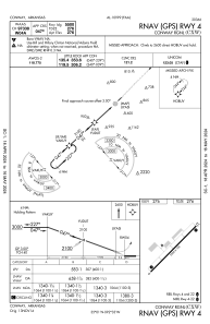
IAC chart of KCXW
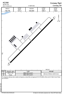
 ADC chart of KCXW
 Satellite view of KCXW

ADC chart of KCXW
Satellite view of KCXW
Sorry, we have no imagery here.
Sorry, we have no imagery here.
Sorry, we have no imagery here.
Sorry, we have no imagery here.
Sorry, we have no imagery here.
Sorry, we have no imagery here.


KCXW - Conway Rgnl
Located in Conway, United States
ICAO - CXW, IATA -
Data provided by AirmateGeneral information
Coordinates: N35°1'12" W92°33'18"
Elevation is 276 feet MSL.
Magnetic variation is 01° East View others Airports in Arkansas
Operational data
Special qualification required
Current time UTC:
Current local time:
Weather
METAR: KCXW 180435Z AUTO 20009KT 4SM HZ 16/03 A3006 RMK A01
Communications frequencies: [VIEW]
Runways:
| RWY identifier | QFU | Length (ft) | Width (ft) | Surface | LDA (ft) |
| 04 | 0° | 5500 | 100 | CONC | |
| 22 | 0° | 5500 | 100 | CONC |
Airport contact information
Address: Conway United States
Other aviation service providers
Flight schools

Superior Aviation Arkansas
Superior Aviation Arkansas
Chris.fisher@superioraviationar.com+1(501)472-2494
Satellite view of KCXW
Sorry, we have no imagery here.
Sorry, we have no imagery here.
Sorry, we have no imagery here.
Sorry, we have no imagery here.
Sorry, we have no imagery here.
Sorry, we have no imagery here.