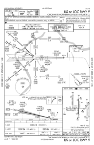
IAC chart of KCVG
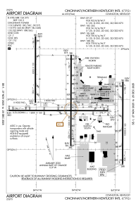
 ADC chart of KCVG
 Satellite view of KCVG
ADC chart of KCVG
Satellite view of KCVG
Sorry, we have no imagery here.
Sorry, we have no imagery here.
Sorry, we have no imagery here.
Sorry, we have no imagery here.
Sorry, we have no imagery here.
Sorry, we have no imagery here.


KCVG - Cincinnati/Northern Kentucky Intl
Located in Covington, United States
ICAO - CVG, IATA - CVG
Data provided by AirmateGeneral information
Coordinates: N39°2'56" W84°40'4"
Elevation is 896 feet MSL.
Magnetic variation is -06° East View others Airports in Kentucky
Operational data
Special qualification required
Current time UTC:
Current local time:
Weather
METAR: KCVG 302208Z 20012G18KT 10SM BKN028 BKN034 OVC070 21/17 A2972 RMK AO2 T02110167
TAF: KCVG 302102Z 3021/3124 20015G25KT P6SM VCSH SCT015 BKN035 FM302300 20013G20KT 4SM -SHRA OVC035 TEMPO 3023/3103 2SM -TSRA OVC022CB FM310400 21012KT P6SM VCSH BKN035 FM311000 29012G18KT P6SM OVC015 FM311900 31013G22KT P6SM OVC025
Communications frequencies: [VIEW]
Runways:
| RWY identifier | QFU | Length (ft) | Width (ft) | Surface | LDA (ft) |
| 09 | 90° | 12001 | 150 | OTHER | 11640 |
| 27 | 270° | 12001 | 150 | OTHER | 12000 |
| 18C | 180° | 11000 | 150 | OTHER | |
| 36C | 0° | 11000 | 150 | OTHER | |
| 18L | 180° | 10000 | 150 | CONC | |
| 36R | 0° | 10000 | 150 | CONC | |
| 18R | 180° | 8000 | 150 | CONC | |
| 36L | 0° | 8000 | 150 | CONC |
Airport contact information
Address: Covington United States
Other aviation service providers
Flight schools

Satellite view of KCVG
Sorry, we have no imagery here.
Sorry, we have no imagery here.
Sorry, we have no imagery here.
Sorry, we have no imagery here.
Sorry, we have no imagery here.
Sorry, we have no imagery here.