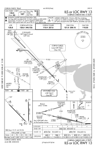
IAC chart of KCRP
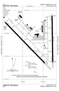
 ADC chart of KCRP
 Satellite view of KCRP
ADC chart of KCRP
Satellite view of KCRP
Sorry, we have no imagery here.
Sorry, we have no imagery here.
Sorry, we have no imagery here.
Sorry, we have no imagery here.
Sorry, we have no imagery here.
Sorry, we have no imagery here.


KCRP - Corpus Christi Intl
Located in Corpus Christi, United States
ICAO - CRP, IATA - CRP
Data provided by AirmateGeneral information
Coordinates: N27°46'20" W97°30'9"
Elevation is 46 feet MSL.
Magnetic variation is 04° East View others Airports in Texas
Operational data
Special qualification required
Current time UTC:
Current local time:
Weather
METAR: KCRP 210751Z 11005KT 10SM FEW009 OVC027 27/26 A2984 RMK AO2 SLP102 T02670256
TAF: KCRP 210556Z 2106/2206 VRB05KT P6SM BKN250 TEMPO 2106/2108 5SM BR BKN015 FM210800 06005KT 6SM BR BKN025 TEMPO 2108/2112 5SM BR OVC015 FM211200 VRB06KT P6SM BKN035 TEMPO 2112/2114 BKN015 FM211400 10009KT P6SM SCT030 BKN250 FM220400 13007KT P6SM SCT040 BKN250
Communications frequencies: [VIEW]
Runways:
| RWY identifier | QFU | Length (ft) | Width (ft) | Surface | LDA (ft) |
| 13 | 136° | 7510 | 150 | ASPH | 7510 |
| 31 | 316° | 7510 | 150 | ASPH | 7510 |
| 18 | 179° | 6080 | 150 | ASPH | 6080 |
| 36 | 359° | 6080 | 150 | ASPH | 6080 |
Airport contact information
Address: Corpus Christi United States
Satellite view of KCRP
Sorry, we have no imagery here.
Sorry, we have no imagery here.
Sorry, we have no imagery here.
Sorry, we have no imagery here.
Sorry, we have no imagery here.
Sorry, we have no imagery here.