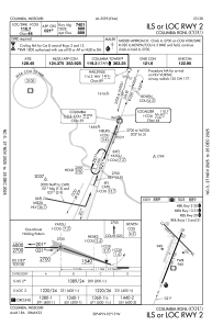
IAC chart of KCOU
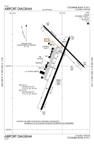
 ADC chart of KCOU
 Satellite view of KCOU

ADC chart of KCOU
Satellite view of KCOU
Sorry, we have no imagery here.
Sorry, we have no imagery here.
Sorry, we have no imagery here.
Sorry, we have no imagery here.
Sorry, we have no imagery here.
Sorry, we have no imagery here.


KCOU - Columbia Rgnl
Located in Columbia, United States
ICAO - COU, IATA - COU
Data provided by AirmateGeneral information
Coordinates: N38°49'4" W92°13'4"
Elevation is 889 feet MSL.
Magnetic variation is 00° East View others Airports in Missouri
Operational data
Special qualification required
Current time UTC:
Current local time:
Weather
METAR: KCOU 162254Z 32016KT 10SM CLR 10/M09 A3002 RMK AO2 SLP168 T01001094
TAF: KCOU 162320Z 1700/1724 31008KT P6SM SKC FM170300 VRB04KT P6SM SKC FM170900 16007KT P6SM SKC FM171500 19012G23KT P6SM SKC
Communications frequencies: [VIEW]
Runways:
| RWY identifier | QFU | Length (ft) | Width (ft) | Surface | LDA (ft) |
| 02 | 21° | 7401 | 150 | CONC | |
| 20 | 201° | 7401 | 150 | CONC | |
| 13 | 135° | 5500 | 100 | CONC | 5500 |
| 31 | 315° | 5500 | 100 | CONC | 5500 |
Airport contact information
Address: Columbia United States
Other aviation service providers
Repair station

Blackhawk Aerospace Technologies Inc.
Blackhawk Aerospace Technologies Inc.
conrad.theisen@blackhawk.aero309-314-4169
Satellite view of KCOU
Sorry, we have no imagery here.
Sorry, we have no imagery here.
Sorry, we have no imagery here.
Sorry, we have no imagery here.
Sorry, we have no imagery here.
Sorry, we have no imagery here.