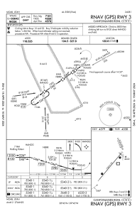
IAC chart of KCNY
 Satellite view of KCNY

Satellite view of KCNY
Sorry, we have no imagery here.
Sorry, we have no imagery here.
Sorry, we have no imagery here.
Sorry, we have no imagery here.
Sorry, we have no imagery here.


KCNY - Canyonlands Rgnl
Located in Moab, United States
ICAO - CNY, IATA - CNY
Data provided by AirmateGeneral information
Coordinates: N38°45'27" W109°45'12"
Elevation is 4579 feet MSL.
Magnetic variation is 10° East View others Airports in Utah
Operational data
Special qualification required
Current time UTC:
Current local time:
Weather
METAR: KCNY 151653Z AUTO 13007KT 10SM FEW100 17/M12 A3015 RMK AO2 SLP172 T01721122
TAF: KCNY 151720Z 1518/1618 12004KT P6SM BKN250 FM152100 28008G16KT P6SM FEW140 BKN250 FM160100 24006KT P6SM BKN250 FM160600 14005KT P6SM FEW110 SCT250 FM161700 23008KT P6SM FEW110 SCT250
Communications frequencies: [VIEW]
Runways:
| RWY identifier | QFU | Length (ft) | Width (ft) | Surface | LDA (ft) |
| 03 | 40° | 7360 | 100 | ASPH | 7101 |
| 21 | 220° | 7360 | 100 | ASPH | 7101 |
| 15 | 158° | 2121 | 60 | GRAVEL | 2000 |
| 33 | 338° | 2121 | 60 | GRAVEL | 2000 |
Airport contact information
Address: Moab United States
Satellite view of KCNY
Sorry, we have no imagery here.
Sorry, we have no imagery here.
Sorry, we have no imagery here.
Sorry, we have no imagery here.
Sorry, we have no imagery here.