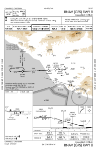
IAC chart of KCMA
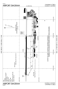
 ADC chart of KCMA
 Satellite view of KCMA
ADC chart of KCMA
Satellite view of KCMA
Sorry, we have no imagery here.
Sorry, we have no imagery here.
Sorry, we have no imagery here.
Sorry, we have no imagery here.
Sorry, we have no imagery here.
Sorry, we have no imagery here.


KCMA - Camarillo
Located in Camarillo, United States
ICAO - CMA, IATA -
Data provided by AirmateGeneral information
Coordinates: N34°12'50" W119°5'40"
Elevation is 76 feet MSL.
Magnetic variation is 14° East View others Airports in California
Operational data
Special qualification required
Current time UTC:
Current local time:
Weather
METAR: KCMA 180455Z AUTO 07004KT 10SM CLR 14/11 A2992 RMK AO2 SLP140 T01390111 $
TAF: KCMA 172331Z 1800/1824 25010KT P6SM SCT025 SCT200 FM180500 VRB03KT P6SM SCT200 FM181400 VRB03KT P6SM BKN025 FM181800 23010KT P6SM FEW250
Communications frequencies: [VIEW]
Runways:
| RWY identifier | QFU | Length (ft) | Width (ft) | Surface | LDA (ft) |
| 08 | 90° | 6013 | 150 | OTHER | |
| 26 | 270° | 6013 | 150 | OTHER | |
| H1 | 0° | 0 | 0 | UNK | |
| H2 | 0° | 0 | 0 | UNK |
Airport contact information
Address: Camarillo United States
Other aviation service providers
Repair station

Flight schools

Atp Flight School (800-All-Atps)
Atp Flight School (800-All-Atps)
info@atpflightschool.com+1(800)255-2877
Satellite view of KCMA
Sorry, we have no imagery here.
Sorry, we have no imagery here.
Sorry, we have no imagery here.
Sorry, we have no imagery here.
Sorry, we have no imagery here.
Sorry, we have no imagery here.