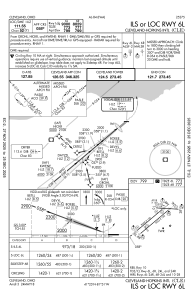
IAC chart of KCLE
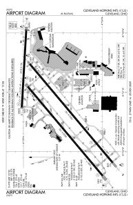
 ADC chart of KCLE
 Satellite view of KCLE
ADC chart of KCLE
Satellite view of KCLE
Sorry, we have no imagery here.
Sorry, we have no imagery here.
Sorry, we have no imagery here.
Sorry, we have no imagery here.
Sorry, we have no imagery here.
Sorry, we have no imagery here.


KCLE - Cleveland-Hopkins Intl
Located in Cleveland, United States
ICAO - CLE, IATA - CLE
Data provided by AirmateGeneral information
Coordinates: N41°24'34" W81°51'17"
Elevation is 799 feet MSL.
Magnetic variation is -08° East View others Airports in Ohio
Operational data
Special qualification required
Current time UTC:
Current local time:
Weather
METAR: KCLE 211051Z 10005KT 10SM FEW007 OVC015 12/11 A2965 RMK AO2 RAE14 SLP055 P0002 T01220111 $
TAF: KCLE 210907Z 2109/2212 06009KT P6SM -RA BKN025 OVC100 FM211200 10009KT 3SM BR VCSH OVC008 FM211500 15008KT 3SM BR BKN003 FM212000 27008KT 5SM -SHRA BR OVC015 FM220000 24009KT 2SM -SHRA BR BKN007
Communications frequencies: [VIEW]
Runways:
| RWY identifier | QFU | Length (ft) | Width (ft) | Surface | LDA (ft) |
| 06L | 50° | 9000 | 150 | CONC | 9000 |
| 24R | 230° | 9000 | 150 | CONC | 9000 |
| 06R | 50° | 9953 | 150 | CONC | 8029 |
| 24L | 230° | 9953 | 150 | CONC | 9956 |
| 10 | 93° | 6018 | 150 | OTHER | 6018 |
| 28 | 273° | 6018 | 150 | OTHER | 6018 |
Airport contact information
Address: Cleveland United States
Satellite view of KCLE
Sorry, we have no imagery here.
Sorry, we have no imagery here.
Sorry, we have no imagery here.
Sorry, we have no imagery here.
Sorry, we have no imagery here.
Sorry, we have no imagery here.