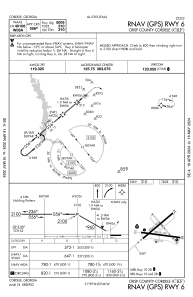
IAC chart of KCKF
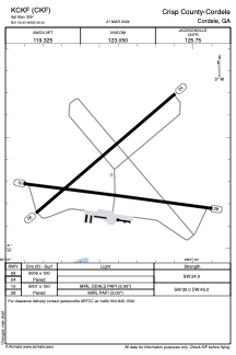
 ADC chart of KCKF
 Satellite view of KCKF

ADC chart of KCKF
Satellite view of KCKF
Sorry, we have no imagery here.
Sorry, we have no imagery here.
Sorry, we have no imagery here.
Sorry, we have no imagery here.
Sorry, we have no imagery here.
Sorry, we have no imagery here.


KCKF - Crisp County-Cordele
Located in Cordele, United States
ICAO - CKF, IATA -
Data provided by AirmateGeneral information
Coordinates: N31°59'20" W83°46'26"
Elevation is 309 feet MSL.
Magnetic variation is -06° East View others Airports in Georgia
Operational data
Special qualification required
Current time UTC:
Current local time:
Weather
METAR: KCKF 210015Z AUTO 35006KT 10SM CLR A3033 RMK AO2
Communications frequencies: [VIEW]
Runways:
| RWY identifier | QFU | Length (ft) | Width (ft) | Surface | LDA (ft) |
| 06 | 50° | 5008 | 100 | ASPH | |
| 24 | 230° | 5008 | 100 | ASPH | |
| 10 | 98° | 5001 | 150 | ASPH | |
| 28 | 278° | 5001 | 150 | ASPH |
Airport contact information
Address: Cordele United States
Satellite view of KCKF
Sorry, we have no imagery here.
Sorry, we have no imagery here.
Sorry, we have no imagery here.
Sorry, we have no imagery here.
Sorry, we have no imagery here.
Sorry, we have no imagery here.