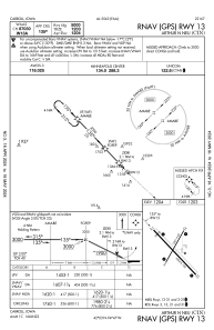
IAC chart of KCIN
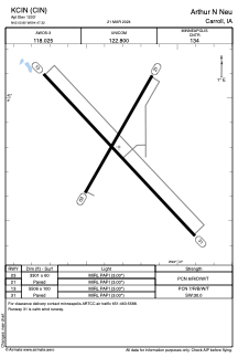
 ADC chart of KCIN
 Satellite view of KCIN
ADC chart of KCIN
Satellite view of KCIN
Sorry, we have no imagery here.
Sorry, we have no imagery here.
Sorry, we have no imagery here.
Sorry, we have no imagery here.
Sorry, we have no imagery here.
Sorry, we have no imagery here.


KCIN - Arthur N Neu
Located in Carroll, United States
ICAO - CIN, IATA - CIN
Data provided by AirmateGeneral information
Coordinates: N42°2'48" W94°47'19"
Elevation is 1203 feet MSL.
Magnetic variation is 02° East View others Airports in Iowa
Operational data
Special qualification required
Current time UTC:
Current local time:
Weather
METAR: KCIN 221755Z AUTO 15014G19KT 10SM CLR 09/M01 A2996 RMK AO2
Communications frequencies: [VIEW]
Runways:
| RWY identifier | QFU | Length (ft) | Width (ft) | Surface | LDA (ft) |
| 03 | 30° | 3301 | 60 | CONC | |
| 21 | 210° | 3301 | 60 | CONC | |
| 13 | 137° | 5506 | 100 | CONC | |
| 31 | 317° | 5506 | 100 | CONC |
Airport contact information
Address: Carroll United States
Other aviation service providers
Flight schools

Satellite view of KCIN
Sorry, we have no imagery here.
Sorry, we have no imagery here.
Sorry, we have no imagery here.
Sorry, we have no imagery here.
Sorry, we have no imagery here.
Sorry, we have no imagery here.