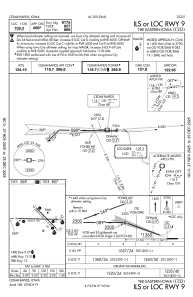
IAC chart of KCID
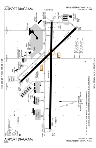
 ADC chart of KCID
 Satellite view of KCID
ADC chart of KCID
Satellite view of KCID
Sorry, we have no imagery here.
Sorry, we have no imagery here.
Sorry, we have no imagery here.
Sorry, we have no imagery here.
Sorry, we have no imagery here.
Sorry, we have no imagery here.


KCID - The Eastern Iowa
Located in Cedar Rapids, United States
ICAO - CID, IATA - CID
Data provided by AirmateGeneral information
Coordinates: N41°53'5" W91°42'39"
Elevation is 869 feet MSL.
Magnetic variation is 02° East View others Airports in Iowa
Operational data
Special qualification required
Current time UTC:
Current local time:
Weather
METAR: KCID 280952Z 15013KT 10SM FEW015 FEW090 13/09 A2995 RMK AO2 SLP141 T01330094 $
TAF: KCID 280736Z 2808/2906 16014G21KT P6SM OVC020 TEMPO 2808/2809 4SM -TSRA BKN015CB FM281400 17022G28KT P6SM BKN015 FM281800 19026G36KT P6SM BKN040 FM290000 20024G30KT P6SM OVC070 FM290300 22021G27KT P6SM OVC250
Communications frequencies: [VIEW]
Runways:
| RWY identifier | QFU | Length (ft) | Width (ft) | Surface | LDA (ft) |
| 09 | 91° | 8600 | 150 | CONC | 8175 |
| 27 | 271° | 8600 | 150 | CONC | 8175 |
| 13 | 136° | 6200 | 150 | CONC | 6200 |
| 31 | 316° | 6200 | 150 | CONC | 6200 |
Airport contact information
Address: Cedar Rapids United States
Other aviation service providers
Flight schools

Satellite view of KCID
Sorry, we have no imagery here.
Sorry, we have no imagery here.
Sorry, we have no imagery here.
Sorry, we have no imagery here.
Sorry, we have no imagery here.
Sorry, we have no imagery here.