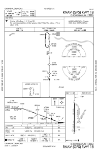
IAC chart of KCHK
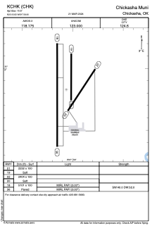
 ADC chart of KCHK
 Satellite view of KCHK
ADC chart of KCHK
Satellite view of KCHK
Sorry, we have no imagery here.
Sorry, we have no imagery here.
Sorry, we have no imagery here.
Sorry, we have no imagery here.
Sorry, we have no imagery here.
Sorry, we have no imagery here.


KCHK - Chickasha Muni
Located in Chickasha, United States
ICAO - CHK, IATA - CHK
Data provided by AirmateGeneral information
Coordinates: N35°5'50" W97°58'4"
Elevation is 1151 feet MSL.
Magnetic variation is 04° East View others Airports in Oklahoma
Operational data
Special qualification required
Current time UTC:
Current local time:
Weather
METAR: KCHK 170735Z AUTO 19009KT 10SM CLR 09/M02 A3010 RMK AO2 T00901019
Communications frequencies: [VIEW]
Runways:
| RWY identifier | QFU | Length (ft) | Width (ft) | Surface | LDA (ft) |
| 01 | 0° | 2232 | 100 | GRASS | |
| 19 | 180° | 2232 | 100 | GRASS | |
| 02 | 33° | 2404 | 100 | GRASS | |
| 20 | 213° | 2404 | 100 | GRASS | |
| 18 | 180° | 5101 | 100 | CONC | |
| 36 | 0° | 5101 | 100 | CONC |
Airport contact information
Address: Chickasha United States
Other aviation service providers
Flight schools

Satellite view of KCHK
Sorry, we have no imagery here.
Sorry, we have no imagery here.
Sorry, we have no imagery here.
Sorry, we have no imagery here.
Sorry, we have no imagery here.
Sorry, we have no imagery here.