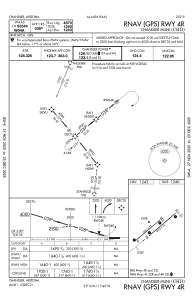
IAC chart of KCHD
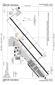
 ADC chart of KCHD
 Satellite view of KCHD
ADC chart of KCHD
Satellite view of KCHD
Sorry, we have no imagery here.
Sorry, we have no imagery here.
Sorry, we have no imagery here.
Sorry, we have no imagery here.
Sorry, we have no imagery here.
Sorry, we have no imagery here.


KCHD - Chandler Muni
Located in Chandler, United States
ICAO - CHD, IATA -
Data provided by AirmateGeneral information
Coordinates: N33°16'9" W111°48'40"
Elevation is 1243 feet MSL.
Magnetic variation is 12° East View others Airports in Arizona
Operational data
Special qualification required
Current time UTC:
Current local time:
Weather
METAR: KCHD 201547Z VRB05KT 10SM CLR 28/M02 A2997
Communications frequencies: [VIEW]
Runways:
| RWY identifier | QFU | Length (ft) | Width (ft) | Surface | LDA (ft) |
| 04L | 50° | 4401 | 75 | ASPH | |
| 22R | 230° | 4401 | 75 | ASPH | |
| 04R | 50° | 4870 | 75 | ASPH | |
| 22L | 230° | 4870 | 75 | ASPH | |
| H1 | 0° | 0 | 0 | UNK |
Airport contact information
Address: Chandler United States
Other aviation service providers
Repair station

Flight schools

Satellite view of KCHD
Sorry, we have no imagery here.
Sorry, we have no imagery here.
Sorry, we have no imagery here.
Sorry, we have no imagery here.
Sorry, we have no imagery here.
Sorry, we have no imagery here.