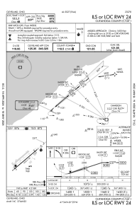
IAC chart of KCGF
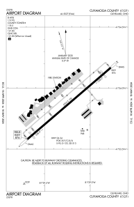
 ADC chart of KCGF
 Satellite view of KCGF
ADC chart of KCGF
Satellite view of KCGF
Sorry, we have no imagery here.
Sorry, we have no imagery here.
Sorry, we have no imagery here.
Sorry, we have no imagery here.
Sorry, we have no imagery here.
Sorry, we have no imagery here.


KCGF - Cuyahoga County
Located in Cleveland, United States
ICAO - CGF, IATA - CGF
Data provided by AirmateGeneral information
Coordinates: N41°33'52" W81°29'14"
Elevation is 876 feet MSL.
Magnetic variation is -08° East View others Airports in Ohio
Operational data
Special qualification required
Current time UTC:
Current local time:
Weather
METAR: KCGF 171745Z 33009KT 270V010 10SM SCT024 01/M04 A3020
Communications frequencies: [VIEW]
Runways:
| RWY identifier | QFU | Length (ft) | Width (ft) | Surface | LDA (ft) |
| 06 | 49° | 5502 | 100 | ASPH | 5184 |
| 24 | 229° | 5502 | 100 | ASPH | 5000 |
Airport contact information
Address: Cleveland United States
Other aviation service providers
Flight schools

Satellite view of KCGF
Sorry, we have no imagery here.
Sorry, we have no imagery here.
Sorry, we have no imagery here.
Sorry, we have no imagery here.
Sorry, we have no imagery here.
Sorry, we have no imagery here.