IAC chart of KCFV
 ADC chart of KCFV
 Satellite view of KCFV
ADC chart of KCFV
Satellite view of KCFV
Sorry, we have no imagery here.
Sorry, we have no imagery here.
Sorry, we have no imagery here.
Sorry, we have no imagery here.
Sorry, we have no imagery here.
Sorry, we have no imagery here.


KCFV - Coffeyville Muni
Located in Coffeyville, United States
ICAO - CFV, IATA - CFV
Data provided by AirmateGeneral information
Coordinates: N37°5'38" W95°34'19"
Elevation is 754 feet MSL.
Magnetic variation is 05° East View others Airports in Kansas
Operational data
Special qualification required
Current time UTC:
Current local time:
Weather
METAR: KCFV 201952Z AUTO 29015G27KT 10SM CLR 23/09 A2978 RMK AO2 PK WND 28027/1946 SLP080 T02280089
Communications frequencies: [VIEW]
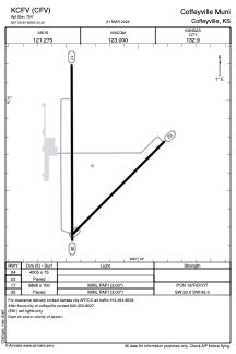
Runways:
| RWY identifier | QFU | Length (ft) | Width (ft) | Surface | LDA (ft) |
| 04 | 45° | 4005 | 75 | ASPH | |
| 22 | 225° | 4005 | 75 | ASPH | |
| 17 | 180° | 5868 | 100 | ASPH | |
| 35 | 360° | 5868 | 100 | ASPH |
Airport contact information
Address: Coffeyville United States
Satellite view of KCFV
Sorry, we have no imagery here.
Sorry, we have no imagery here.
Sorry, we have no imagery here.
Sorry, we have no imagery here.
Sorry, we have no imagery here.
Sorry, we have no imagery here.