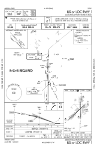
IAC chart of KCAK
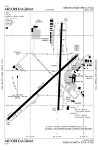
 ADC chart of KCAK
 Satellite view of KCAK

ADC chart of KCAK
Satellite view of KCAK
Sorry, we have no imagery here.
Sorry, we have no imagery here.
Sorry, we have no imagery here.
Sorry, we have no imagery here.
Sorry, we have no imagery here.
Sorry, we have no imagery here.


KCAK - Akron-Canton Rgnl
Located in Akron, United States
ICAO - CAK, IATA - CAK
Data provided by AirmateGeneral information
Coordinates: N40°54'54" W81°26'37"
Elevation is 1225 feet MSL.
Magnetic variation is -07° East View others Airports in Ohio
Operational data
Special qualification required
Current time UTC:
Current local time:
Weather
METAR: KCAK 170751Z 33011KT 10SM BKN019 OVC024 00/M03 A2997 RMK AO2 SNE07 SLP154 P0000 T00001033
Communications frequencies: [VIEW]
Runways:
| RWY identifier | QFU | Length (ft) | Width (ft) | Surface | LDA (ft) |
| 01 | 2° | 7601 | 150 | ASPH | 7007 |
| 19 | 182° | 7601 | 150 | ASPH | 7007 |
| 05 | 47° | 8204 | 150 | ASPH | 8204 |
| 23 | 227° | 8204 | 150 | ASPH | 8204 |
Airport contact information
Address: Akron United States
Other aviation service providers
Flight schools

Satellite view of KCAK
Sorry, we have no imagery here.
Sorry, we have no imagery here.
Sorry, we have no imagery here.
Sorry, we have no imagery here.
Sorry, we have no imagery here.
Sorry, we have no imagery here.