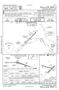
IAC chart of KCAE
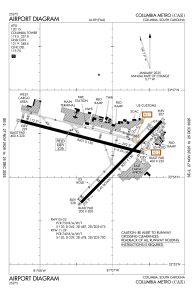
 ADC chart of KCAE
 Satellite view of KCAE
ADC chart of KCAE
Satellite view of KCAE
Sorry, we have no imagery here.
Sorry, we have no imagery here.
Sorry, we have no imagery here.
Sorry, we have no imagery here.
Sorry, we have no imagery here.
Sorry, we have no imagery here.


KCAE - Columbia Metro
Located in Columbia, United States
ICAO - CAE, IATA - CAE
Data provided by AirmateGeneral information
Coordinates: N33°56'20" W81°7'10"
Elevation is 236 feet MSL.
Magnetic variation is -07° East View others Airports in South Carolina
Operational data
Special qualification required
Current time UTC:
Current local time:
Weather
TAF: KCAE 300520Z 3006/3106 15004KT P6SM SCT250 FM301100 VRB03KT P6SM SCT015 OVC100 TEMPO 3011/3015 BKN025 FM301500 17011KT P6SM SCT020 OVC040 FM301900 18011KT P6SM VCSH SCT025 OVC050 TEMPO 3020/3024 3SM -TSRA BKN035CB FM310300 17006KT 5SM BR BKN015
Communications frequencies: [VIEW]
Runways:
| RWY identifier | QFU | Length (ft) | Width (ft) | Surface | LDA (ft) |
| 05 | 45° | 8001 | 150 | OTHER | 7001 |
| 23 | 225° | 8001 | 150 | OTHER | 7001 |
| 11 | 105° | 8601 | 150 | CONC | 8601 |
| 29 | 285° | 8601 | 150 | CONC | 8506 |
| H1 | 0° | 0 | 0 | UNK |
Airport contact information
Address: Columbia United States
Satellite view of KCAE
Sorry, we have no imagery here.
Sorry, we have no imagery here.
Sorry, we have no imagery here.
Sorry, we have no imagery here.
Sorry, we have no imagery here.
Sorry, we have no imagery here.