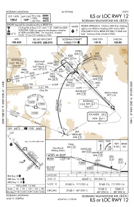
IAC chart of KBZN
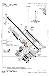
 ADC chart of KBZN
 Satellite view of KBZN
ADC chart of KBZN
Satellite view of KBZN
Sorry, we have no imagery here.
Sorry, we have no imagery here.
Sorry, we have no imagery here.
Sorry, we have no imagery here.
Sorry, we have no imagery here.
Sorry, we have no imagery here.


KBZN - Bozeman Yellowstone Intl
Located in Bozeman, United States
ICAO - BZN, IATA - BZN
Data provided by AirmateGeneral information
Coordinates: N45°46'38" W111°9'1"
Elevation is 4473 feet MSL.
Magnetic variation is 13° East View others Airports in Montana
Operational data
Special qualification required
Current time UTC:
Current local time:
Weather
METAR: KBZN 250856Z AUTO 25009KT 10SM CLR 03/M04 A3015 RMK AO2 SLP214 T00281039 56003
TAF: KBZN 250539Z 2506/2612 12008KT P6SM SCT080 WS020/10035KT FM251000 VRB05KT 6SM BR FEW015 SCT080 FM251600 09007KT P6SM SCT080 FM252000 10011G19KT P6SM BKN070 BKN250 FM260300 VRB06KT P6SM SCT070 BKN200
Communications frequencies: [VIEW]
Runways:
| RWY identifier | QFU | Length (ft) | Width (ft) | Surface | LDA (ft) |
| 03 | 46° | 2650 | 75 | ASPH | 2650 |
| 21 | 226° | 2650 | 75 | ASPH | 2650 |
| 11 | 136° | 5050 | 75 | ASPH | 5050 |
| 29 | 316° | 5050 | 75 | ASPH | 5050 |
| 11G | 136° | 2802 | 80 | GRASS | |
| 29G | 316° | 2802 | 80 | GRASS | |
| 12 | 136° | 8994 | 150 | ASPH | 8994 |
| 30 | 316° | 8994 | 150 | ASPH | 8994 |
Airport contact information
Address: Bozeman United States
Other aviation service providers
Repair station

Flight schools

Satellite view of KBZN
Sorry, we have no imagery here.
Sorry, we have no imagery here.
Sorry, we have no imagery here.
Sorry, we have no imagery here.
Sorry, we have no imagery here.
Sorry, we have no imagery here.