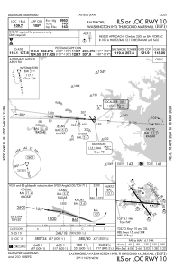
IAC chart of KBWI
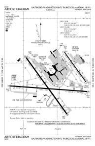
 ADC chart of KBWI
 Satellite view of KBWI
ADC chart of KBWI
Satellite view of KBWI
Sorry, we have no imagery here.
Sorry, we have no imagery here.
Sorry, we have no imagery here.
Sorry, we have no imagery here.
Sorry, we have no imagery here.
Sorry, we have no imagery here.


KBWI - Baltimore/Washington Intl Thurgood Marshall
Located in Baltimore, United States
ICAO - BWI, IATA - BWI
Data provided by AirmateGeneral information
Coordinates: N39°10'33" W76°40'8"
Elevation is 143 feet MSL.
Magnetic variation is -11° East View others Airports in Maryland
Operational data
Special qualification required
Current time UTC:
Current local time:
Weather
METAR: KBWI 291754Z 25019G25KT 10SM FEW080 SCT120 BKN140 BKN250 29/06 A3003 RMK AO2 PK WND 28029/1744 SLP169 T02890061 10294 20178 58017 $
TAF: KBWI 291726Z 2918/3024 23008G17KT P6SM SCT100 BKN200 FM300100 19004KT P6SM SCT150 BKN250 FM301700 20009G17KT P6SM BKN090 FM301900 20011G19KT P6SM FEW035 SCT080
Communications frequencies: [VIEW]
Runways:
| RWY identifier | QFU | Length (ft) | Width (ft) | Surface | LDA (ft) |
| 10 | 94° | 10503 | 150 | ASPH | 9953 |
| 28 | 274° | 10503 | 150 | ASPH | 9803 |
| 15L | 144° | 5000 | 100 | ASPH | 5000 |
| 33R | 324° | 5000 | 100 | ASPH | 5000 |
| 15R | 144° | 9501 | 150 | ASPH | 8301 |
| 33L | 324° | 9501 | 150 | ASPH | 8301 |
Airport contact information
Address: Baltimore United States
Satellite view of KBWI
Sorry, we have no imagery here.
Sorry, we have no imagery here.
Sorry, we have no imagery here.
Sorry, we have no imagery here.
Sorry, we have no imagery here.
Sorry, we have no imagery here.