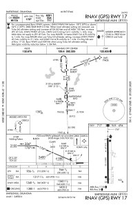
IAC chart of KBVO
 Satellite view of KBVO
Satellite view of KBVO
Sorry, we have no imagery here.
Sorry, we have no imagery here.
Sorry, we have no imagery here.
Sorry, we have no imagery here.
Sorry, we have no imagery here.
Sorry, we have no imagery here.


KBVO - Bartlesville Muni
Located in Bartlesville, United States
ICAO - BVO, IATA - BVO
Data provided by AirmateGeneral information
Coordinates: N36°45'48" W96°0'40"
Elevation is 716 feet MSL.
Magnetic variation is 03° East View others Airports in Oklahoma
Operational data
Special qualification required
Current time UTC:
Current local time:
Weather
METAR: KBVO 171653Z 04009KT 10SM CLR 24/07 A2996 RMK AO2 SLP138 T02390072
TAF: KBVO 171120Z 1712/1812 07006KT P6SM BKN250 FM172100 09006KT P6SM BKN050 BKN150 OVC200 PROB30 1801/1807 4SM -TSRA BKN050CB FM181000 08002KT P6SM OVC040
Communications frequencies: [VIEW]
Runways:
| RWY identifier | QFU | Length (ft) | Width (ft) | Surface | LDA (ft) |
| 17 | 179° | 6850 | 100 | CONC | 6201 |
| 35 | 359° | 6850 | 100 | CONC | 6201 |
Airport contact information
Address: Bartlesville United States
Satellite view of KBVO
Sorry, we have no imagery here.
Sorry, we have no imagery here.
Sorry, we have no imagery here.
Sorry, we have no imagery here.
Sorry, we have no imagery here.
Sorry, we have no imagery here.