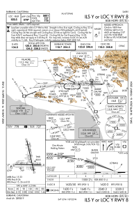
IAC chart of KBUR
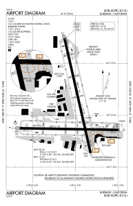
 ADC chart of KBUR
 Satellite view of KBUR
ADC chart of KBUR
Satellite view of KBUR
Sorry, we have no imagery here.
Sorry, we have no imagery here.
Sorry, we have no imagery here.
Sorry, we have no imagery here.
Sorry, we have no imagery here.
Sorry, we have no imagery here.


KBUR - Bob Hope
Located in Burbank, United States
ICAO - BUR, IATA - BUR
Data provided by AirmateGeneral information
Coordinates: N34°12'2" W118°21'31"
Elevation is 778 feet MSL.
Magnetic variation is 12° East View others Airports in California
Operational data
Special qualification required
Current time UTC:
Current local time:
Weather
METAR: KBUR 181114Z 15003KT 10SM SCT014 13/11 A2994 RMK AO2 T01330106
TAF: KBUR 180605Z 1806/1906 VRB03KT P6SM SCT040 FM181500 15008KT P6SM BKN050 FM190000 17008KT P6SM SCT050 FM190500 VRB03KT P6SM SKC
Communications frequencies: [VIEW]
Runways:
| RWY identifier | QFU | Length (ft) | Width (ft) | Surface | LDA (ft) |
| 08 | 91° | 5802 | 150 | OTHER | 5801 |
| 26 | 271° | 5802 | 150 | OTHER | 5801 |
| 15 | 167° | 6886 | 150 | OTHER | 5976 |
| 33 | 347° | 6886 | 150 | OTHER | 6535 |
Airport contact information
Address: Burbank United States
Other aviation service providers
Flight schools

Satellite view of KBUR
Sorry, we have no imagery here.
Sorry, we have no imagery here.
Sorry, we have no imagery here.
Sorry, we have no imagery here.
Sorry, we have no imagery here.
Sorry, we have no imagery here.