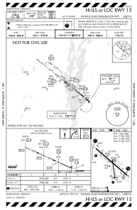
IAC chart of KBTV
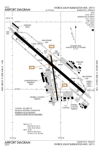
 ADC chart of KBTV
 Satellite view of KBTV
ADC chart of KBTV
Satellite view of KBTV
Sorry, we have no imagery here.
Sorry, we have no imagery here.
Sorry, we have no imagery here.
Sorry, we have no imagery here.
Sorry, we have no imagery here.
Sorry, we have no imagery here.


KBTV - Patrick Leahy Burlington Intl
Located in Burlington, United States
ICAO - BTV, IATA - BTV
Data provided by AirmateGeneral information
Coordinates: N44°28'19" W73°9'12"
Elevation is 334 feet MSL.
Magnetic variation is -15° East View others Airports in Vermont
Operational data
Special qualification required
Current time UTC:
Current local time:
Weather
METAR: KBTV 290112Z 04007KT 7SM -SN OVC048 02/M07 A3012 RMK AO2 SNB11 P0000 T00221067
TAF: KBTV 282336Z 2900/2924 01007KT P6SM OVC080 FM290500 01005KT 6SM -SN OVC035 TEMPO 2905/2907 1 1/2SM -SN OVC022 FM290700 35005KT 1 1/2SM -SN OVC009 TEMPO 2907/2911 1/2SM SN OVC009 FM291400 34005KT 4SM -SN BR OVC011
Communications frequencies: [VIEW]
Runways:
| RWY identifier | QFU | Length (ft) | Width (ft) | Surface | LDA (ft) |
| 01 | 351° | 4112 | 75 | ASPH | 3386 |
| 19 | 171° | 4112 | 75 | ASPH | 3386 |
| 15 | 131° | 8319 | 150 | OTHER | 7820 |
| 33 | 311° | 8319 | 150 | OTHER | 7820 |
Airport contact information
Address: Burlington United States
Other aviation service providers
Flight schools

Satellite view of KBTV
Sorry, we have no imagery here.
Sorry, we have no imagery here.
Sorry, we have no imagery here.
Sorry, we have no imagery here.
Sorry, we have no imagery here.
Sorry, we have no imagery here.