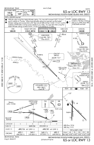
IAC chart of KBRO
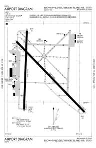
 ADC chart of KBRO
 Satellite view of KBRO
ADC chart of KBRO
Satellite view of KBRO
Sorry, we have no imagery here.
Sorry, we have no imagery here.
Sorry, we have no imagery here.
Sorry, we have no imagery here.
Sorry, we have no imagery here.
Sorry, we have no imagery here.


KBRO - Brownsville/South Padre Island Intl
Located in Brownsville, United States
ICAO - BRO, IATA - BRO
Data provided by AirmateGeneral information
Coordinates: N25°54'22" W97°25'34"
Elevation is 22 feet MSL.
Magnetic variation is 03° East View others Airports in Texas
Operational data
Special qualification required
Current time UTC:
Current local time:
Weather
METAR: KBRO 150753Z AUTO 17009KT 4SM BR CLR 22/20 A2943 RMK AO2 SLP964 T02170200
TAF: KBRO 150531Z 1506/1606 17015G25KT 4SM BR BKN006 FM151200 35015G25KT P6SM SKC FM152000 08010KT P6SM SKC FM160300 VRB05KT P6SM SKC
Communications frequencies: [VIEW]
Runways:
| RWY identifier | QFU | Length (ft) | Width (ft) | Surface | LDA (ft) |
| 13 | 135° | 7399 | 150 | ASPH | 7399 |
| 31 | 315° | 7399 | 150 | ASPH | 7399 |
| 18 | 182° | 6000 | 150 | ASPH | 5810 |
| 36 | 2° | 6000 | 150 | ASPH | 5532 |
Airport contact information
Address: Brownsville United States
Other aviation service providers
Flight schools

Satellite view of KBRO
Sorry, we have no imagery here.
Sorry, we have no imagery here.
Sorry, we have no imagery here.
Sorry, we have no imagery here.
Sorry, we have no imagery here.
Sorry, we have no imagery here.