IAC chart of KBRD
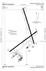
 ADC chart of KBRD
 Satellite view of KBRD

ADC chart of KBRD
Satellite view of KBRD
Sorry, we have no imagery here.
Sorry, we have no imagery here.
Sorry, we have no imagery here.
Sorry, we have no imagery here.
Sorry, we have no imagery here.
Sorry, we have no imagery here.


KBRD - Brainerd Lakes Rgnl
Located in Brainerd, United States
ICAO - BRD, IATA - BRD
Data provided by AirmateGeneral information
Coordinates: N46°24'15" W94°8'2"
Elevation is 1232 feet MSL.
Magnetic variation is 03° East View others Airports in Minnesota
Operational data
Special qualification required
Current time UTC:
Current local time:
Weather
METAR: KBRD 170053Z AUTO 09003KT 10SM FEW022 BKN047 OVC070 M01/M10 A2988 RMK AO2 SLP141 T10111100
TAF: KBRD 162323Z 1700/1724 VRB04KT P6SM VCSH BKN080 FM170300 16007G16KT P6SM BKN100 FM170700 14006KT P6SM BKN050 WS020/20036KT FM171400 16010G20KT P6SM BKN100 FM171700 VRB06KT P6SM FEW020 SCT100
Communications frequencies: [VIEW]
Runways:
| RWY identifier | QFU | Length (ft) | Width (ft) | Surface | LDA (ft) |
| 05 | 54° | 6512 | 150 | CONC | |
| 23 | 234° | 6512 | 150 | CONC | |
| 16 | 163° | 7100 | 150 | CONC | |
| 34 | 343° | 7100 | 150 | CONC | |
| H1 | 0° | 0 | 0 | UNK |
Airport contact information
Address: Brainerd United States

Satellite view of KBRD
Sorry, we have no imagery here.
Sorry, we have no imagery here.
Sorry, we have no imagery here.
Sorry, we have no imagery here.
Sorry, we have no imagery here.
Sorry, we have no imagery here.