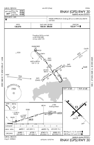
IAC chart of KBNO
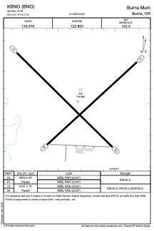
 ADC chart of KBNO
 Satellite view of KBNO
ADC chart of KBNO
Satellite view of KBNO
Sorry, we have no imagery here.
Sorry, we have no imagery here.
Sorry, we have no imagery here.
Sorry, we have no imagery here.
Sorry, we have no imagery here.
Sorry, we have no imagery here.


KBNO - Burns Muni
Located in Burns, United States
ICAO - BNO, IATA - BNO
Data provided by AirmateGeneral information
Coordinates: N43°35'31" W118°57'20"
Elevation is 4148 feet MSL.
Magnetic variation is 18° East View others Airports in Oregon
Operational data
Special qualification required
Current time UTC:
Current local time:
Weather
TAF: KBNO 161737Z 1618/1718 22025G35KT P6SM BKN060 FM162000 22030G45KT P6SM BKN060 FM170100 23020G35KT 6SM -SHRA SCT035 OVC050 FM170300 25018G26KT 2SM -SHSNRA SCT015 OVC025 FM170600 25010KT P6SM VCSH BKN080 FM171100 VRB05KT P6SM SCT080
Communications frequencies: [VIEW]
Runways:
| RWY identifier | QFU | Length (ft) | Width (ft) | Surface | LDA (ft) |
| 03 | 48° | 4600 | 60 | CONC | |
| 21 | 228° | 4600 | 60 | CONC | |
| 12 | 135° | 5101 | 75 | CONC | |
| 30 | 315° | 5101 | 75 | CONC |
Airport contact information
Address: Burns United States
Satellite view of KBNO
Sorry, we have no imagery here.
Sorry, we have no imagery here.
Sorry, we have no imagery here.
Sorry, we have no imagery here.
Sorry, we have no imagery here.
Sorry, we have no imagery here.