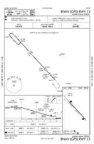
IAC chart of KBHK
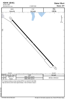
 ADC chart of KBHK
 Satellite view of KBHK
ADC chart of KBHK
Satellite view of KBHK
Sorry, we have no imagery here.
Sorry, we have no imagery here.
Sorry, we have no imagery here.
Sorry, we have no imagery here.
Sorry, we have no imagery here.
Sorry, we have no imagery here.


KBHK - Baker Muni
Located in Baker, United States
ICAO - BHK, IATA -
Data provided by AirmateGeneral information
Coordinates: N46°20'48" W104°15'29"
Elevation is 2980 feet MSL.
Magnetic variation is 09° East View others Airports in Montana
Operational data
Special qualification required
Current time UTC:
Current local time:
Weather
METAR: KBHK 200558Z AUTO 00000KT 10SM -RA BKN010 OVC022 02/02 A2989 RMK AO2 P0000 T00220017
Communications frequencies: [VIEW]
Runways:
| RWY identifier | QFU | Length (ft) | Width (ft) | Surface | LDA (ft) |
| 13 | 138° | 5904 | 75 | ASPH | |
| 31 | 318° | 5904 | 75 | ASPH |
Airport contact information
Address: Baker United States
Satellite view of KBHK
Sorry, we have no imagery here.
Sorry, we have no imagery here.
Sorry, we have no imagery here.
Sorry, we have no imagery here.
Sorry, we have no imagery here.
Sorry, we have no imagery here.