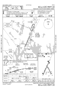
IAC chart of KBHB
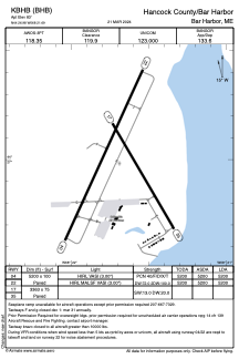
 ADC chart of KBHB
 Satellite view of KBHB
ADC chart of KBHB
Satellite view of KBHB
Sorry, we have no imagery here.
Sorry, we have no imagery here.
Sorry, we have no imagery here.
Sorry, we have no imagery here.
Sorry, we have no imagery here.
Sorry, we have no imagery here.


KBHB - Hancock County/Bar Harbor
Located in Bar Harbor, United States
ICAO - BHB, IATA - BHB
Data provided by AirmateGeneral information
Coordinates: N44°26'59" W68°21'41"
Elevation is 83 feet MSL.
Magnetic variation is -19° East View others Airports in Maine
Operational data
Special qualification required
Current time UTC:
Current local time:
Weather
METAR: KBHB 171056Z AUTO 07004KT 1/2SM FG OVC002 09/09 A2980 RMK AO2 SLP091 T00940094 RVRNO
TAF: KBHB 170538Z 1706/1806 10004KT 2SM BR OVC002 FM171500 13007KT P6SM VCSH OVC004 FM180000 12008G15KT 3SM -SHRA BR OVC002
Communications frequencies: [VIEW]
Runways:
| RWY identifier | QFU | Length (ft) | Width (ft) | Surface | LDA (ft) |
| 04 | 25° | 5200 | 100 | ASPH | 5200 |
| 22 | 205° | 5200 | 100 | ASPH | 5200 |
| 17 | 150° | 3363 | 75 | ASPH | |
| 35 | 330° | 3363 | 75 | ASPH |
Airport contact information
Address: Bar Harbor United States
Other aviation service providers
Flight schools

Satellite view of KBHB
Sorry, we have no imagery here.
Sorry, we have no imagery here.
Sorry, we have no imagery here.
Sorry, we have no imagery here.
Sorry, we have no imagery here.
Sorry, we have no imagery here.