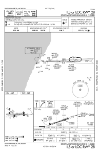
IAC chart of KBEH
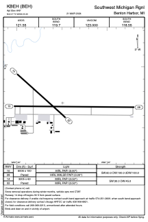
 ADC chart of KBEH
 Satellite view of KBEH
ADC chart of KBEH
Satellite view of KBEH
Sorry, we have no imagery here.
Sorry, we have no imagery here.
Sorry, we have no imagery here.
Sorry, we have no imagery here.
Sorry, we have no imagery here.
Sorry, we have no imagery here.


KBEH - Southwest Michigan Rgnl
Located in Benton Harbor, United States
ICAO - BEH, IATA - BEH
Data provided by AirmateGeneral information
Coordinates: N42°7'42" W86°25'30"
Elevation is 649 feet MSL.
Magnetic variation is -04° East View others Airports in Michigan
Operational data
Special qualification required
Current time UTC:
Current local time:
Weather
METAR: KBEH 290053Z AUTO 22019G35KT 10SM SCT110 23/08 A2974 RMK AO2 PK WND 21036/0041 SLP069 T02330083
Communications frequencies: [VIEW]
Runways:
| RWY identifier | QFU | Length (ft) | Width (ft) | Surface | LDA (ft) |
| 10 | 90° | 6006 | 100 | ASPH | |
| 28 | 270° | 6006 | 100 | ASPH | |
| 14 | 132° | 3205 | 60 | ASPH | |
| 32 | 312° | 3205 | 60 | ASPH |
Airport contact information
Address: Benton Harbor United States
Other aviation service providers
Flight schools

Satellite view of KBEH
Sorry, we have no imagery here.
Sorry, we have no imagery here.
Sorry, we have no imagery here.
Sorry, we have no imagery here.
Sorry, we have no imagery here.
Sorry, we have no imagery here.