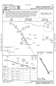
IAC chart of KBBW
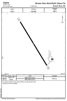
 ADC chart of KBBW
 Satellite view of KBBW
ADC chart of KBBW
Satellite view of KBBW
Sorry, we have no imagery here.
Sorry, we have no imagery here.
Sorry, we have no imagery here.
Sorry, we have no imagery here.
Sorry, we have no imagery here.
Sorry, we have no imagery here.


KBBW - Broken Bow Muni/Keith Glaze Fld
Located in Broken Bow, United States
ICAO - BBW, IATA - BBW
Data provided by AirmateGeneral information
Coordinates: N41°26'11" W99°38'32"
Elevation is 2546 feet MSL.
Magnetic variation is 08° East View others Airports in Nebraska
Operational data
Special qualification required
Current time UTC:
Current local time:
Weather
METAR: KBBW 301353Z AUTO 16004KT 10SM CLR 15/11 A3014 RMK AO2 SLP198 T01500111
Communications frequencies: [VIEW]
Runways:
| RWY identifier | QFU | Length (ft) | Width (ft) | Surface | LDA (ft) |
| 14 | 149° | 4203 | 75 | CONC | |
| 32 | 329° | 4203 | 75 | CONC |
Airport contact information
Address: Broken Bow United States
Satellite view of KBBW
Sorry, we have no imagery here.
Sorry, we have no imagery here.
Sorry, we have no imagery here.
Sorry, we have no imagery here.
Sorry, we have no imagery here.
Sorry, we have no imagery here.