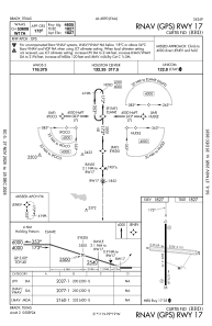
IAC chart of KBBD
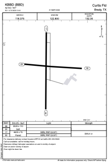
 ADC chart of KBBD
 Satellite view of KBBD
ADC chart of KBBD
Satellite view of KBBD
Sorry, we have no imagery here.
Sorry, we have no imagery here.
Sorry, we have no imagery here.
Sorry, we have no imagery here.
Sorry, we have no imagery here.
Sorry, we have no imagery here.


KBBD - Curtis Fld
Located in Brady, United States
ICAO - BBD, IATA - BBD
Data provided by AirmateGeneral information
Coordinates: N31°10'45" W99°19'26"
Elevation is 1827 feet MSL.
Magnetic variation is 07° East View others Airports in Texas
Operational data
Special qualification required
Current time UTC:
Current local time:
Weather
METAR: KBBD 180815Z AUTO 16012KT 10SM FEW018 24/21 A2979 RMK AO2
TAF: KBBD 180520Z 1806/1906 15010KT P6SM SCT100 BKN200 FM181100 17012KT P6SM BKN025 FM181500 18015G24KT P6SM SCT050 BKN250
Communications frequencies: [VIEW]
Runways:
| RWY identifier | QFU | Length (ft) | Width (ft) | Surface | LDA (ft) |
| 08 | 93° | 3520 | 110 | GRASS | |
| 26 | 273° | 3520 | 110 | GRASS | |
| 17 | 180° | 4605 | 75 | ASPH | |
| 35 | 0° | 4605 | 75 | ASPH |
Airport contact information
Address: Brady United States
