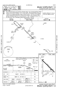
IAC chart of KBAC
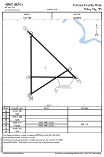
 ADC chart of KBAC
 Satellite view of KBAC
ADC chart of KBAC
Satellite view of KBAC
Sorry, we have no imagery here.
Sorry, we have no imagery here.
Sorry, we have no imagery here.
Sorry, we have no imagery here.
Sorry, we have no imagery here.
Sorry, we have no imagery here.


KBAC - Barnes County Muni
Located in Valley City, United States
ICAO - BAC, IATA -
Data provided by AirmateGeneral information
Coordinates: N46°56'28" W98°1'5"
Elevation is 1401 feet MSL.
Magnetic variation is 07° East View others Airports in North Dakota
Operational data
Special qualification required
Current time UTC:
Current local time:
Weather
METAR: KBAC 212335Z AUTO 01010KT 10SM CLR M03/M14 A2990 RMK AO2
Communications frequencies: [VIEW]
Runways:
| RWY identifier | QFU | Length (ft) | Width (ft) | Surface | LDA (ft) |
| 05 | 58° | 2525 | 120 | GRASS | |
| 23 | 238° | 2525 | 120 | GRASS | |
| 08 | 90° | 2520 | 120 | GRASS | |
| 26 | 270° | 2520 | 120 | GRASS | |
| 13 | 134° | 4201 | 75 | CONC | |
| 31 | 314° | 4201 | 75 | CONC | |
| 17 | 180° | 3539 | 100 | GRASS | |
| 35 | 360° | 3539 | 100 | GRASS |
Airport contact information
Address: Valley City United States
Satellite view of KBAC
Sorry, we have no imagery here.
Sorry, we have no imagery here.
Sorry, we have no imagery here.
Sorry, we have no imagery here.
Sorry, we have no imagery here.
Sorry, we have no imagery here.