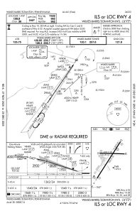
IAC chart of KAVP
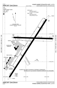
 ADC chart of KAVP
 Satellite view of KAVP

ADC chart of KAVP
Satellite view of KAVP
Sorry, we have no imagery here.
Sorry, we have no imagery here.
Sorry, we have no imagery here.
Sorry, we have no imagery here.
Sorry, we have no imagery here.
Sorry, we have no imagery here.


KAVP - Wilkes-Barre/Scranton Intl
Located in Wilkes-Barre/Scranton, United States
ICAO - AVP, IATA - AVP
Data provided by AirmateGeneral information
Coordinates: N41°20'18" W75°43'24"
Elevation is 961 feet MSL.
Magnetic variation is -11° East View others Airports in Pennsylvania
Operational data
Special qualification required
Current time UTC:
Current local time:
Weather
METAR: KAVP 190054Z 31011KT 10SM CLR M09/M21 A3023 RMK AO2 PK WND 32027/0042 SLP253 T10891206
TAF: KAVP 182339Z 1900/1924 29012KT P6SM SKC FM191600 32008KT P6SM BKN100
Communications frequencies: [VIEW]
Runways:
| RWY identifier | QFU | Length (ft) | Width (ft) | Surface | LDA (ft) |
| 04 | 33° | 7502 | 150 | ASPH | 7502 |
| 22 | 213° | 7502 | 150 | ASPH | 7502 |
| 10 | 92° | 4300 | 150 | ASPH | 4300 |
| 28 | 272° | 4300 | 150 | ASPH | 4300 |
Airport contact information
Address: Wilkes-Barre/Scranton United States
Other aviation service providers
Flight schools

Aviation Technologies, Inc.
Aviation Technologies, Inc.
cphebus@aviation-technologies.com+1(570)457-4485
Satellite view of KAVP
Sorry, we have no imagery here.
Sorry, we have no imagery here.
Sorry, we have no imagery here.
Sorry, we have no imagery here.
Sorry, we have no imagery here.
Sorry, we have no imagery here.