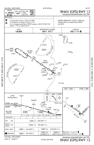
IAC chart of KAUW
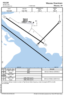
 ADC chart of KAUW
 Satellite view of KAUW
ADC chart of KAUW
Satellite view of KAUW
Sorry, we have no imagery here.
Sorry, we have no imagery here.
Sorry, we have no imagery here.
Sorry, we have no imagery here.
Sorry, we have no imagery here.


KAUW - Wausau Downtown
Located in Wausau, United States
ICAO - AUW, IATA - AUW
Data provided by AirmateGeneral information
Coordinates: N44°55'35" W89°37'37"
Elevation is 1201 feet MSL.
Magnetic variation is -03° East View others Airports in Wisconsin
Operational data
Special qualification required
Current time UTC:
Current local time:
Weather
METAR: KAUW 220354Z AUTO 33013G28KT 10SM BKN065 01/M11 A2965 RMK AO2 PK WND 34031/0344 WSHFT 0302 SLP056 T00061111
TAF: KAUW 212336Z 2200/2224 30010G21KT P6SM SCT040 BKN060 PROB30 2200/2202 6SM -RA OVC035 FM220300 34014G27KT P6SM FEW040 SCT150 FM220600 33012G21KT P6SM FEW250 FM221200 34008KT P6SM FEW030 FEW250 FM221600 31005KT P6SM SKC FM222000 22005KT P6SM SKC
Communications frequencies: [VIEW]
Runways:
| RWY identifier | QFU | Length (ft) | Width (ft) | Surface | LDA (ft) |
| 05 | 44° | 3041 | 100 | ASPH | |
| 23 | 224° | 3041 | 100 | ASPH | |
| 12W | 0° | 8000 | 300 | WATER | |
| 30W | 0° | 8000 | 300 | WATER | |
| 13 | 124° | 5200 | 100 | ASPH | |
| 31 | 304° | 5200 | 100 | ASPH |
Airport contact information
Address: Wausau United States
Other aviation service providers
Flight schools

Satellite view of KAUW
Sorry, we have no imagery here.
Sorry, we have no imagery here.
Sorry, we have no imagery here.
Sorry, we have no imagery here.
Sorry, we have no imagery here.