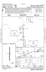
IAC chart of KASJ
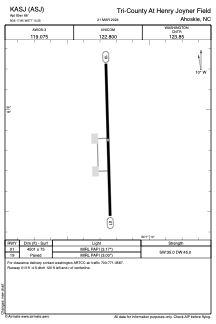
 ADC chart of KASJ
 Satellite view of KASJ

ADC chart of KASJ
Satellite view of KASJ
Sorry, we have no imagery here.
Sorry, we have no imagery here.
Sorry, we have no imagery here.
Sorry, we have no imagery here.
Sorry, we have no imagery here.
Sorry, we have no imagery here.


KASJ - Tri-County At Henry Joyner Fld
Located in Ahoskie, United States
ICAO - ASJ, IATA -
Data provided by AirmateGeneral information
Coordinates: N36°17'51" W77°10'15"
Elevation is 66 feet MSL.
Magnetic variation is -10° East View others Airports in North Carolina
Operational data
Special qualification required
Current time UTC:
Current local time:
Weather
METAR: KASJ 030645Z AUTO 00000KT 10SM CLR M03/M06 A3023 RMK AO2 T10351064
Communications frequencies: [VIEW]
Runways:
| RWY identifier | QFU | Length (ft) | Width (ft) | Surface | LDA (ft) |
| 01 | 358° | 4501 | 75 | ASPH | |
| 19 | 178° | 4501 | 75 | ASPH |
Airport contact information
Address: Ahoskie United States
Satellite view of KASJ
Sorry, we have no imagery here.
Sorry, we have no imagery here.
Sorry, we have no imagery here.
Sorry, we have no imagery here.
Sorry, we have no imagery here.
Sorry, we have no imagery here.