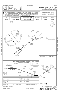
IAC chart of KARB
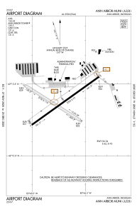
 ADC chart of KARB
 Satellite view of KARB
ADC chart of KARB
Satellite view of KARB
Sorry, we have no imagery here.
Sorry, we have no imagery here.
Sorry, we have no imagery here.
Sorry, we have no imagery here.
Sorry, we have no imagery here.
Sorry, we have no imagery here.


KARB - Ann Arbor Muni
Located in Ann Arbor, United States
ICAO - ARB, IATA - ARB
Data provided by AirmateGeneral information
Coordinates: N42°13'23" W83°44'45"
Elevation is 839 feet MSL.
Magnetic variation is -05° East View others Airports in Michigan
Operational data
Special qualification required
Current time UTC:
Current local time:
Weather
METAR: KARB 220053Z AUTO 33004KT 5SM -RA BR SCT007 BKN012 OVC018 11/09 A2969 RMK AO2 SLP057 P0003 T01060094
Communications frequencies: [VIEW]
Runways:
| RWY identifier | QFU | Length (ft) | Width (ft) | Surface | LDA (ft) |
| 06 | 55° | 3505 | 75 | CONC | |
| 24 | 235° | 3505 | 75 | CONC | |
| 12 | 122° | 2750 | 110 | GRASS | |
| 30 | 302° | 2750 | 110 | GRASS |
Airport contact information
Address: Ann Arbor United States
Other aviation service providers
Flight schools

Satellite view of KARB
Sorry, we have no imagery here.
Sorry, we have no imagery here.
Sorry, we have no imagery here.
Sorry, we have no imagery here.
Sorry, we have no imagery here.
Sorry, we have no imagery here.