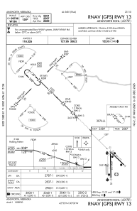
IAC chart of KANW
 Satellite view of KANW
Satellite view of KANW
Sorry, we have no imagery here.
Sorry, we have no imagery here.
Sorry, we have no imagery here.
Sorry, we have no imagery here.
Sorry, we have no imagery here.
Sorry, we have no imagery here.


KANW - Ainsworth Rgnl
Located in Ainsworth, United States
ICAO - ANW, IATA - ANW
Data provided by AirmateGeneral information
Coordinates: N42°34'45" W99°59'35"
Elevation is 2588 feet MSL.
Magnetic variation is 06° East View others Airports in Nebraska
Operational data
Special qualification required
Current time UTC:
Current local time:
Weather
METAR: KANW 170055Z AUTO 20003KT 10SM CLR 11/M08 A2974 RMK AO2 T01111080
Communications frequencies: [VIEW]
Runways:
| RWY identifier | QFU | Length (ft) | Width (ft) | Surface | LDA (ft) |
| 13 | 134° | 5501 | 75 | ASPH | |
| 31 | 314° | 5501 | 75 | ASPH | |
| 17 | 179° | 6824 | 110 | ASPH | |
| 35 | 359° | 6824 | 110 | ASPH | |
| H1 | 0° | 0 | 0 | UNK |
Airport contact information
Address: Ainsworth United States
Satellite view of KANW
Sorry, we have no imagery here.
Sorry, we have no imagery here.
Sorry, we have no imagery here.
Sorry, we have no imagery here.
Sorry, we have no imagery here.
Sorry, we have no imagery here.