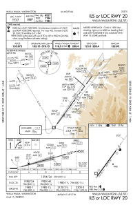
IAC chart of KALW
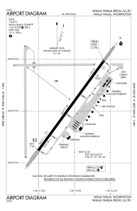
 ADC chart of KALW
 Satellite view of KALW

ADC chart of KALW
Satellite view of KALW
Sorry, we have no imagery here.
Sorry, we have no imagery here.
Sorry, we have no imagery here.
Sorry, we have no imagery here.
Sorry, we have no imagery here.
Sorry, we have no imagery here.


KALW - Walla Walla Rgnl
Located in Walla Walla, United States
ICAO - ALW, IATA - ALW
Data provided by AirmateGeneral information
Coordinates: N46°5'33" W118°17'3"
Elevation is 1194 feet MSL.
Magnetic variation is 14° East View others Airports in Washington
Operational data
Special qualification required
Current time UTC:
Current local time:
Weather
METAR: KALW 162353Z 21009KT 10SM FEW120 09/01 A2964 RMK AO2 SLP041 T00890011 10089 20078 58003
TAF: KALW 162334Z 1700/1724 22010KT P6SM OVC120 FM170300 18007KT P6SM BKN050 BKN100 FM172100 22009KT P6SM SCT050 BKN100
Communications frequencies: [VIEW]
Runways:
| RWY identifier | QFU | Length (ft) | Width (ft) | Surface | LDA (ft) |
| 02 | 36° | 6527 | 150 | CONC | 6527 |
| 20 | 216° | 6527 | 150 | CONC | 6527 |
Airport contact information
Address: Walla Walla United States
Other aviation service providers
Flight schools

Satellite view of KALW
Sorry, we have no imagery here.
Sorry, we have no imagery here.
Sorry, we have no imagery here.
Sorry, we have no imagery here.
Sorry, we have no imagery here.
Sorry, we have no imagery here.