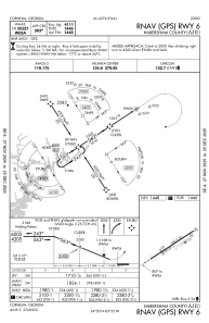
IAC chart of KAJR
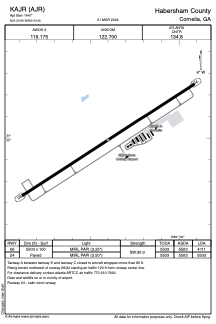
 ADC chart of KAJR
 Satellite view of KAJR

ADC chart of KAJR
Satellite view of KAJR
Sorry, we have no imagery here.
Sorry, we have no imagery here.
Sorry, we have no imagery here.
Sorry, we have no imagery here.
Sorry, we have no imagery here.
Sorry, we have no imagery here.


KAJR - Habersham County
Located in Cornelia, United States
ICAO - AJR, IATA -
Data provided by AirmateGeneral information
Coordinates: N34°29'59" W83°33'24"
Elevation is 1447 feet MSL.
Magnetic variation is -06° East View others Airports in Georgia
Operational data
Special qualification required
Current time UTC:
Current local time:
Weather
METAR: KAJR 162335Z AUTO 26009KT 10SM SCT095 SCT110 19/02 A2979 RMK AO2 T01850022
Communications frequencies: [VIEW]
Runways:
| RWY identifier | QFU | Length (ft) | Width (ft) | Surface | LDA (ft) |
| 06 | 57° | 5503 | 100 | ASPH | 4111 |
| 24 | 237° | 5503 | 100 | ASPH | 5503 |
Airport contact information
Address: Cornelia United States
Other aviation service providers
Flight schools

Satellite view of KAJR
Sorry, we have no imagery here.
Sorry, we have no imagery here.
Sorry, we have no imagery here.
Sorry, we have no imagery here.
Sorry, we have no imagery here.
Sorry, we have no imagery here.