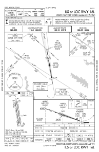
IAC chart of KAFW
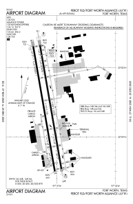
 ADC chart of KAFW
 Satellite view of KAFW
ADC chart of KAFW
Satellite view of KAFW
Sorry, we have no imagery here.
Sorry, we have no imagery here.
Sorry, we have no imagery here.
Sorry, we have no imagery here.
Sorry, we have no imagery here.
Sorry, we have no imagery here.


KAFW - Perot Fld/Fort Worth Alliance
Located in Fort Worth, United States
ICAO - AFW, IATA - AFW
Data provided by AirmateGeneral information
Coordinates: N32°59'25" W97°19'10"
Elevation is 723 feet MSL.
Magnetic variation is 04° East View others Airports in Texas
Operational data
Special qualification required
Current time UTC:
Current local time:
Weather
METAR: KAFW 191553Z 17015G20KT 6SM HZ OVC020 26/22 A2969 RMK AO2 PK WND 17029/1515 RAB25E34 SLP040 P0000 T02560222
TAF: KAFW 191501Z 1915/2012 17014G24KT P6SM BKN016 FM191600 18017G27KT P6SM VCTS BKN024CB FM191900 18020G30KT P6SM BKN040 BKN250 FM192200 18020G30KT P6SM VCTS BKN040CB TEMPO 1923/2001 -TSRA FM200300 18011KT P6SM SCT080 BKN250
Communications frequencies: [VIEW]
Runways:
| RWY identifier | QFU | Length (ft) | Width (ft) | Surface | LDA (ft) |
| 16L | 170° | 11000 | 150 | CONC | 10600 |
| 34R | 350° | 11000 | 150 | CONC | 11000 |
| 16R | 170° | 11125 | 150 | CONC | 10410 |
| 34L | 350° | 11125 | 150 | CONC | 10409 |
Airport contact information
Address: Fort Worth United States
Satellite view of KAFW
Sorry, we have no imagery here.
Sorry, we have no imagery here.
Sorry, we have no imagery here.
Sorry, we have no imagery here.
Sorry, we have no imagery here.
Sorry, we have no imagery here.