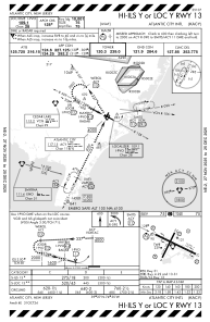
IAC chart of KACY
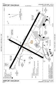
 ADC chart of KACY
 Satellite view of KACY
ADC chart of KACY
Satellite view of KACY
Sorry, we have no imagery here.
Sorry, we have no imagery here.
Sorry, we have no imagery here.
Sorry, we have no imagery here.
Sorry, we have no imagery here.
Sorry, we have no imagery here.


KACY - Atlantic City Intl
Located in Atlantic City, United States
ICAO - ACY, IATA - ACY
Data provided by AirmateGeneral information
Coordinates: N39°27'27" W74°34'38"
Elevation is 74 feet MSL.
Magnetic variation is -10° East View others Airports in New Jersey
Operational data
Special qualification required
Current time UTC:
Current local time:
Weather
METAR: KACY 041554Z 19010G19KT 10SM OVC075 08/02 A3025 RMK AO2 SLP242 T00830022
TAF: KACY 041132Z 0412/0512 18005KT P6SM BKN100 FM041500 20012G20KT P6SM BKN200 FM050200 19010G19KT P6SM SCT250 WS020/21040KT FM051100 18013G22KT P6SM SCT045 BKN080 WS020/19045KT
Communications frequencies: [VIEW]
Runways:
| RWY identifier | QFU | Length (ft) | Width (ft) | Surface | LDA (ft) |
| 04 | 28° | 6145 | 150 | OTHER | 6145 |
| 22 | 208° | 6145 | 150 | OTHER | 6145 |
| 13 | 118° | 10001 | 150 | ASPH | 10001 |
| 31 | 298° | 10001 | 150 | ASPH | 10001 |
| H1 | 0° | 0 | 0 | UNK |
Airport contact information
Address: Atlantic City United States
Satellite view of KACY
Sorry, we have no imagery here.
Sorry, we have no imagery here.
Sorry, we have no imagery here.
Sorry, we have no imagery here.
Sorry, we have no imagery here.
Sorry, we have no imagery here.