


KACV - California Redwood Coast-Humboldt County
Located in Arcata/Eureka, United States
ICAO - ACV, IATA - ACV
Data provided by AirmateGeneral information
Coordinates: N40°58'40" W124°6'30"
Elevation is 222 feet MSL.
Magnetic variation is 17° East View others Airports in California
Operational data
Special qualification required
Current time UTC:
Current local time:
Weather
METAR: KACV 171753Z AUTO 08007KT 10SM -RA FEW041 BKN060 OVC070 06/06 A2998 RMK AO2 SLP158 P0006 60046 T00610061 10083 20061 53022
TAF: KACV 171734Z 1718/1818 04006KT 6SM -SHRA SCT025 BKN035 OVC050 FM171930 33009KT 3SM -SHRA BR SCT009 BKN035 TEMPO 1720/1722 33012KT 6SM -SHRA BR OVC029 FM172200 33012KT 6SM -SHRA BR SCT029 BKN050 FM180000 34012G18KT P6SM SCT050 BKN100 FM180300 35006KT P6SM SCT050 FM180900 VRB05KT 6SM BR SCT025 BKN050
Communications frequencies: [VIEW]
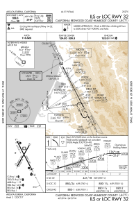
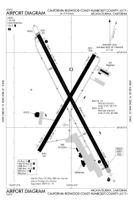
Runways:
| RWY identifier | QFU | Length (ft) | Width (ft) | Surface | LDA (ft) |
| 01 | 30° | 4501 | 150 | ASPH | 4501 |
| 19 | 210° | 4501 | 150 | ASPH | 4501 |
| 14 | 153° | 6046 | 150 | ASPH | 5601 |
| 32 | 333° | 6046 | 150 | ASPH | 5846 |
Airport contact information
Address: Arcata/Eureka United States