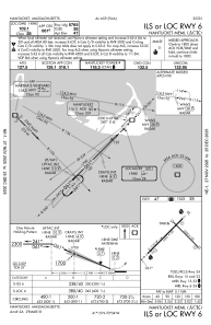
IAC chart of KACK
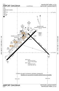
 ADC chart of KACK
 Satellite view of KACK
ADC chart of KACK
Satellite view of KACK
Sorry, we have no imagery here.
Sorry, we have no imagery here.
Sorry, we have no imagery here.
Sorry, we have no imagery here.
Sorry, we have no imagery here.
Sorry, we have no imagery here.


KACK - Nantucket Meml
Located in Nantucket, United States
ICAO - ACK, IATA - ACK
Data provided by AirmateGeneral information
Coordinates: N41°15'12" W70°3'38"
Elevation is 47 feet MSL.
Magnetic variation is -16° East View others Airports in Massachusetts
Operational data
Special qualification required
Current time UTC:
Current local time:
Weather
METAR: KACK 061321Z 23012KT 1/4SM R24/2000V2600FT FG VV002 09/08 A2978 RMK AO2 T00890083 $
TAF: KACK 061125Z 0612/0712 22011KT 1/4SM FG OVC002 FM061400 26011KT 2SM BR OVC003 FM061700 31008KT 3SM BR OVC008 FM062100 31009KT P6SM OVC015 FM062300 31005KT P6SM BKN040 FM070600 36007KT P6SM -RA OVC050 FM070900 03010KT 5SM -RA BR OVC015
Communications frequencies: [VIEW]
Runways:
| RWY identifier | QFU | Length (ft) | Width (ft) | Surface | LDA (ft) |
| 06 | 45° | 6303 | 150 | ASPH | 5765 |
| 24 | 225° | 6303 | 150 | ASPH | 6303 |
| 15 | 135° | 4500 | 100 | ASPH | 4500 |
| 33 | 315° | 4500 | 100 | ASPH | 4500 |
Airport contact information
Address: Nantucket United States
Satellite view of KACK
Sorry, we have no imagery here.
Sorry, we have no imagery here.
Sorry, we have no imagery here.
Sorry, we have no imagery here.
Sorry, we have no imagery here.
Sorry, we have no imagery here.