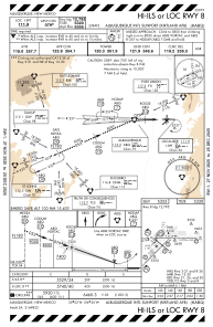
IAC chart of KABQ
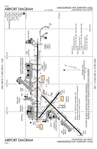
 ADC chart of KABQ
 Satellite view of KABQ
ADC chart of KABQ
Satellite view of KABQ
Sorry, we have no imagery here.
Sorry, we have no imagery here.
Sorry, we have no imagery here.
Sorry, we have no imagery here.
Sorry, we have no imagery here.
Sorry, we have no imagery here.


KABQ - Albuquerque Intl Sunport
Located in Albuquerque, United States
ICAO - ABQ, IATA - ABQ
Data provided by AirmateGeneral information
Coordinates: N35°2'20" W106°36'30"
Elevation is 5354 feet MSL.
Magnetic variation is 11° East View others Airports in New Mexico
Operational data
Special qualification required
Current time UTC:
Current local time:
Weather
METAR: KABQ 201752Z COR 33007KT 10SM CLR 16/M08 A3016 RMK AO2 SLP166 T01611083 10161 20044 58004 $
TAF: KABQ 201723Z 2018/2118 30013G23KT P6SM SKC FM210300 01007KT P6SM SKC
Communications frequencies: [VIEW]
Runways:
| RWY identifier | QFU | Length (ft) | Width (ft) | Surface | LDA (ft) |
| 03 | 45° | 10000 | 150 | CONC | 10000 |
| 21 | 225° | 10000 | 150 | CONC | 10000 |
| 08 | 90° | 13793 | 150 | CONC | 12793 |
| 26 | 270° | 13793 | 150 | CONC | 13793 |
| 12 | 129° | 6000 | 150 | CONC | 6000 |
| 30 | 309° | 6000 | 150 | CONC | 6000 |
Airport contact information
Address: Albuquerque United States
Other aviation service providers
Flight schools

Vertical Limit Aviation, Llc
Vertical Limit Aviation, Llc
dchristian@enchantmenthelicopters.com+1(505)831-4354
Satellite view of KABQ
Sorry, we have no imagery here.
Sorry, we have no imagery here.
Sorry, we have no imagery here.
Sorry, we have no imagery here.
Sorry, we have no imagery here.
Sorry, we have no imagery here.