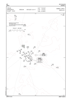
VAC chart of HLLS
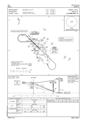
 IAC chart of HLLS
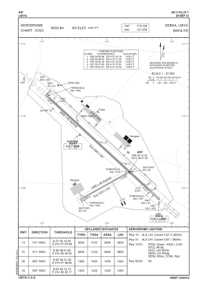
 ADC chart of HLLS
 Satellite view of HLLS

IAC chart of HLLSADC chart of HLLS
Satellite view of HLLS
Sorry, we have no imagery here.
Sorry, we have no imagery here.
Sorry, we have no imagery here.
Sorry, we have no imagery here.
Sorry, we have no imagery here.
Sorry, we have no imagery here.


HLLS - Sebha/International
Located in Sebha, Libyan Arab Jamahiriya
ICAO - HLLS, IATA - SEB
Data provided by AirmateGeneral information
Coordinates: N26°59'13" E14°28'21"
Elevation is 1427 feet MSL.
Magnetic variation is 3° East View others Airports in Sabha District
Operational data
Special qualification required
Current time UTC:
Current local time:
Weather at : - ( 0 km )
METAR: KGUL 180625Z AUTO 14008KT 5SM BR SCT013 26/24 A2991 RMK A01
Communications frequencies: [VIEW]
Runways:
| RWY identifier | QFU | Length (ft) | Width (ft) | Surface | LDA (ft) |
| 06 | 61° | 4447 | 95 | ASPH | |
| 24 | 241° | 4447 | 95 | ASPH | |
| 13R | 133° | 11782 | 136 | ASPH CONC | |
| 31L | 313° | 11782 | 136 | ASPH CONC | |
| 31R | 313° | 8148 | 97 | ASPH CONC | |
| 13L | 133° | 8148 | 97 | ASPH CONC |
Airport contact information
Address: Sebha Libyan Arab Jamahiriya
Satellite view of HLLS
Sorry, we have no imagery here.
Sorry, we have no imagery here.
Sorry, we have no imagery here.
Sorry, we have no imagery here.
Sorry, we have no imagery here.
Sorry, we have no imagery here.