VAC chart of FTAA
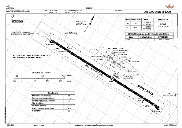
 ADC chart of FTAA
 Satellite view of FTAA
ADC chart of FTAA
Satellite view of FTAA
Sorry, we have no imagery here.
Sorry, we have no imagery here.
Sorry, we have no imagery here.
Sorry, we have no imagery here.
Sorry, we have no imagery here.
Sorry, we have no imagery here.


FTAA - Amdjarass
Located in , Chad
ICAO - , IATA -
Data provided by AirmateGeneral information
Coordinates: N15°58'15" E22°46'21"
Elevation is 2753 feet MSL.
Operational data
Special qualification required
Current time UTC:
Current local time:
Weather at : - ( 0 km )
METAR: KJXI 292215Z AUTO 14008G15KT 10SM SCT029 SCT080 26/17 A2979 RMK AO2 T02610171
Communications frequencies: [VIEW]
Runways:
| RWY identifier | QFU | Length (ft) | Width (ft) | Surface | LDA (ft) |
| 09 | 0° | 0 | 0 | UNK | |
| 27 | 0° | 0 | 0 | UNK |
Airport contact information
Address: Chad
Satellite view of FTAA
Sorry, we have no imagery here.
Sorry, we have no imagery here.
Sorry, we have no imagery here.
Sorry, we have no imagery here.
Sorry, we have no imagery here.
Sorry, we have no imagery here.