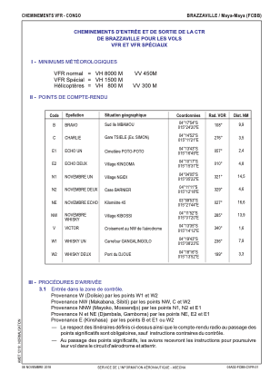
VAC chart of FCBB
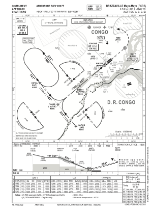
 IAC chart of FCBB
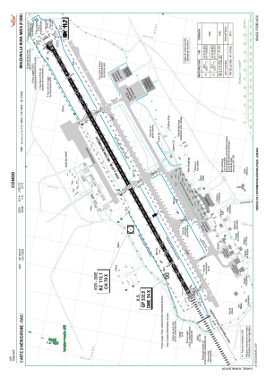
 ADC chart of FCBB
 Satellite view of FCBB
IAC chart of FCBBADC chart of FCBB
Satellite view of FCBB
Sorry, we have no imagery here.
Sorry, we have no imagery here.
Sorry, we have no imagery here.
Sorry, we have no imagery here.
Sorry, we have no imagery here.
Sorry, we have no imagery here.


FCBB - Brazzaville / Maya-Maya
Located in Brazzaville, Congo
ICAO - FCBB, IATA - BZV
Data provided by AirmateGeneral information
Coordinates: S4°15'2" E15°15'5"
Elevation is 1052 feet MSL.
View others Airports in Pool
Operational data
Special qualification required
Current time UTC:
Current local time:
Weather
METAR: FCBB 060300Z VRB01KT 9000 NSC 24/22 Q1011 NOSIG
TAF: TAF FCBB 060020Z 0600/0706 25005KT 9000 FEW018 PROB40 0602/0606 -TSRA BKN015 FEW030CB BECMG 0613/0615 SCT018 FEW030CB BECMG 0618/0620 FEW018 PROB30 0700/0705 -TSRA BKN018 FEW030CB
Communications frequencies: [VIEW]
Runways:
| RWY identifier | QFU | Length (ft) | Width (ft) | Surface | LDA (ft) |
| 05 | 50° | 10827 | 148 | ASP | |
| 23 | 230° | 10827 | 148 | ASP |
Airport contact information
Address: Brazzaville Congo
Satellite view of FCBB
Sorry, we have no imagery here.
Sorry, we have no imagery here.
Sorry, we have no imagery here.
Sorry, we have no imagery here.
Sorry, we have no imagery here.
Sorry, we have no imagery here.