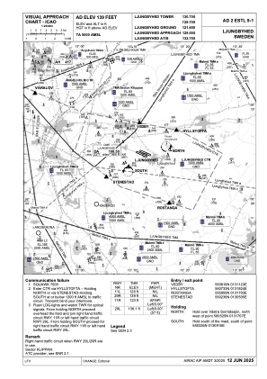
VAC chart of ESTL
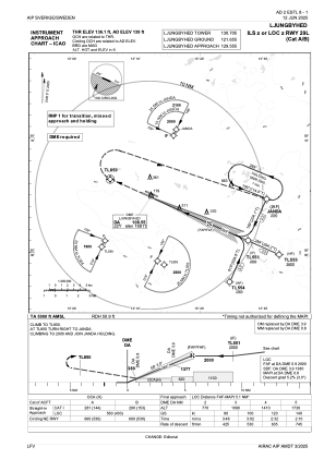
 IAC chart of ESTL
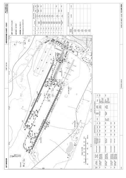
 ADC chart of ESTL
 Satellite view of ESTL
IAC chart of ESTLADC chart of ESTL
Satellite view of ESTL
Sorry, we have no imagery here.
Sorry, we have no imagery here.
Sorry, we have no imagery here.
Sorry, we have no imagery here.
Sorry, we have no imagery here.
Sorry, we have no imagery here.


ESTL - Ljungbyhed
Located in Ljungbyhed, Sweden
ICAO - ESTL, IATA -
Data provided by AirmateGeneral information
Coordinates: N56°5'7" E13°12'25"
Elevation is 139 feet MSL.
Magnetic variation is +4.0° East View others Airports in Skåne län
Operational data
Special qualification required
Current time UTC:
Current local time:
Weather at : ESMS - Malmoe ( 60 km )
METAR: ESMS 311120Z 16009KT 9999 FEW027 BKN041 18/13 Q1009
TAF: TAF ESMS 310827Z 3109/0109 16011KT 9999 SCT018 TEMPO 3109/3124 4000 SHRA BKN014 FEW020CB BECMG 3119/3122 09005KT TEMPO 0100/0105 2000 SHRA BR BKN008 FEW020CB TEMPO 0105/0109 4000 SHRA BKN012 SCT020CB
Communications frequencies: [VIEW]
Runways:
| RWY identifier | QFU | Length (ft) | Width (ft) | Surface | LDA (ft) |
| 11L | 113° | 6555 | 131 | ASP | |
| 29R | 293° | 6555 | 131 | ASP | |
| 11R | 113° | 6516 | 131 | ASP | |
| 29L | 293° | 6516 | 131 | ASP |
Airport contact information
Address: Ljungbyhed Sweden
Other aviation service providers
Aviation club (not for profit)

Lunds Universitet Trafikflyghögskolan
Lunds Universitet Trafikflyghögskolan
thomas.hallstrom@tfhs.lu.se+46435445400
Satellite view of ESTL
Sorry, we have no imagery here.
Sorry, we have no imagery here.
Sorry, we have no imagery here.
Sorry, we have no imagery here.
Sorry, we have no imagery here.
Sorry, we have no imagery here.