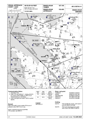
VAC chart of ESTA
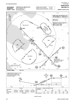
 IAC chart of ESTA
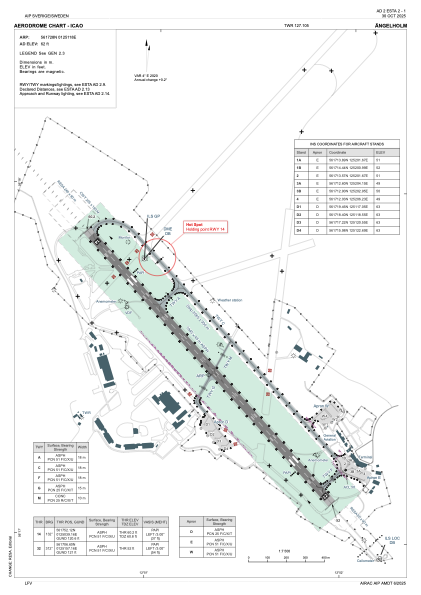
 ADC chart of ESTA
 Satellite view of ESTA

IAC chart of ESTAADC chart of ESTA
Satellite view of ESTA
Sorry, we have no imagery here.
Sorry, we have no imagery here.
Sorry, we have no imagery here.
Sorry, we have no imagery here.
Sorry, we have no imagery here.


ESTA - Aengelholm
Located in Aengelholm, Sweden
ICAO - ESTA, IATA - AGH
Data provided by AirmateGeneral information
Coordinates: N56°17'28" E12°51'18"
Elevation is 62 feet MSL.
Magnetic variation is +4.0° East View others Airports in Skåne län
Operational data
Special qualification required
Current time UTC:
Current local time:
Weather at : ESMT - Halmstad ( 44 km )
METAR: ESMT 191750Z 23005KT CAVOK 02/01 Q1024
TAF: TAF ESMT 191707Z 1918/1920 25006KT CAVOK
Communications frequencies: [VIEW]
Runways:
| RWY identifier | QFU | Length (ft) | Width (ft) | Surface | LDA (ft) |
| 14 | 136° | 6381 | 148 | ASP | |
| 32 | 317° | 6381 | 148 | ASP |
Airport contact information
Address: Aengelholm Sweden
Web: www.aghairport.se
Other aviation service providers
Aviation club (not for profit)

Satellite view of ESTA
Sorry, we have no imagery here.
Sorry, we have no imagery here.
Sorry, we have no imagery here.
Sorry, we have no imagery here.
Sorry, we have no imagery here.